In 2013 the European Union published a register of all the protected wilderness areas in Europe. The mapping that accompanied the register uses digital maps of land use, natural vegetation and remoteness from settlements and roads to create a picture of wilderness areas across Europe. This shows that a little over 42% of the top 1% wildest land in Europe lies within Iceland.
Analyses of detailed data can accurately model and predict the extent of impacts from existing and proposed development on the qualities of wilderness landscapes including natural vegetation patterns, reduced remoteness and increased visual impact. These methods and approaches that have already been used elsewhere (including Scotland, France, Germany, USA, and China) have modified and adjusted to suit the landscape and conditions found in Iceland.
The proposed Hvalá powerplant lies inside the Ófeigsfjörður area of the Drangajökull Peninsula in NW Iceland’s Westfjords Region. The construction of the power plant would involve upgrades to existing access roads to allow for heavy construction vehicles and material transport, the construction of further access roads, building dams, overflows, tunnels and other infrastructure, the raising of lake levels on the Eyvindarfjarðarvatn, Hvalávatn and Nyrðra/Syðra Vatnalautavatn, and result in reduced water levels in the Hvalá and Eyvindarfjarðará rivers (and corresponding impacts on waterfalls), the construction of a work camp, and the construction of either an overhead or underground power line to connect to the existing grid network.
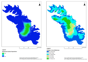
The Drangajökull Peninsula is an area which is at present largely free from visual impact and currently contains almost no modern human infrastructure except for a few small farms and summer dwellings at certain points along the coastal margins. The analyses presented here show that construction of the Hvalá powerplant, should it be consented, would impact significantly on this “impact free” area. It is acknowledged that two further powerplants are envisaged in the area, and that these combined would have significant and lasting impacts on the region, its landscape and its wildlife contrary to The 2013 Nature Conservation Act No.60/2103that “aim(s) to safeguard the characteristics of the areas e.g. to maintain diverse and unusual landscapes, panoramas and/or conserve complete large ecosystems, and ensure that present and future generations can enjoy therein solitude and nature without disturbance from man-made infrastructures or traffic from motor vehicles“.
Analyses show that a development of the scale proposed would have a significant adverse impact on the qualities of this area of wilderness, with the likely outcome that if the development goes ahead the area of wilderness in the vicinity would be reduced by between 26,300-28,400ha or 45-48.5%. A copy of the full report can be found here.